Damming events at Attabad
21 March 2011Lessons have to be learnt and the hazard is far from over. This is the view of Professor David Petley who has been investigating the Attabad landslide in Hunza, Pakistan. Here he gives an indepth look at events before and after the formation of the landslide dam and warns that new hazards may be on the horizon
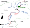
The Hunza River flows in a generally southward direction from Tibet into northern Pakistan, draining a substantial area of the Korakoram mountain chain. The river valley is perhaps best known as the route of the Karakoram Highway, a spectacular mountain road linking Tibet with Pakistan. As such it is of great strategic importance, providing a key link between western China and the Pakistani sea ports on the Arabian Sea.
The valley has a long history of landslides – indeed during the construction of the Karakoram Highway in the 1970s and 80s it is estimated that over 890 workers lost their lives, mostly the victim of landslide and rockfall events. However, natural landslides are also common – indeed the steep valley walls are marked with numerous large landslide scars. These mass movements have frequently led to blockages of the valley, evidenced by the remains of both landslide deposits and sediments from barrier lakes. In 1858 a large landslide occurred at Salmanabad in Hunza, blocking the valley for over six months and generating a lake about 30km in length. The landslide dam breached catastrophically as a result of waves generated by a further landslide into the lake. The resultant flood reportedly caused serious damage along a >400km length of the Hunza and Indus river valleys.
The Attabad landslide
The village of Attabad was located in Hunza, about 130km upstream of the town of Gilgit in Gilgit - Baltistan. The village was located 600m above the main river valley. In 2002 a series of large cracks developed in the slope on the north side of the valley, running through the village and surrounding farmland. Over the following six years these cracks progressively lengthened and widened, extending over hundreds of metres and developing displacements of in excess of a metre. By 2009 the cracks had become sufficiently extensive to require investigation by consultants acting for both Focus Humanitarian Assistance (FHA) and the Geological Survey of Pakistan (GSP). At this stage 12 houses had been seriously damaged. The 2009 GSP report recommended that the slope should be evacuated; this was implemented by FHA.
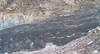
On 4 January 2010 the slope at Attabad failed catastrophically without warning. There was no apparent trigger for the landslide, which occurred in the middle of winter when the atmospheric conditions were dry and cold. The landslide involved a mass of about 45Mm3, although eye-witness reports suggest that it occurred in a series of collapses extending over more than 24 hours.
The landslide has a vertical extent of about 1175m from the top of the landslide scar to the valley floor, and it moved over a horizontal distance of about 1300m. The landslide body blocked the Hunza valley to a depth of about 200m at the highest point and 120m at the saddle, forming an asymmetric deposit in which the highest point is on the far side from the landslide scar. The main deposit is about 300m wide (across the valley) and about 1.5km long (along the valley).
The landslide process appears to have been complex, consisting of two main events associated with the local geological conditions. At the site of the landslide the main valley floor consisted of river gravels overlying a silty-clay lake bed deposit. This deposit had been laid down in the lake that formed behind the aforementioned 1858 landslide at Salmanabad, the site of which was located just 3km downstream of Attabad. The main body of the Attabad landslide descended at high velocity onto this saturated lake deposit, which was in turn mobilised by the impact. The lake bed deposit formed three separate flows. One was apparently pushed against and up the opposite valley wall and then flowed back to be deposited on top of the main landslide mass. The second formed a mudflow that travelled about 1.5km up the Hunza Valley, whilst the third formed a highly energetic mudflow that travelled about 3km down the valley.
In the path of the flow was Sarat, a small hamlet located close to the river. Nineteen people were killed at this site; these were the only fatalities from the landslide. However, in total 141 houses, providing the homes of 1652 people, were destroyed or rendered unsafe.
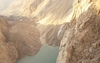
The landslide created a natural dam that blocked the Hunza River, and a lake rapidly started to form behind the barrier. The initial impact of the landslide on the local population was the loss of the road over the 1.5km extent of the main landslide body, which rendered 25,000 people living to the north of the barrier isolated. As the landslide occurred shortly after the mountain pass to Tibet had been closed by snow, this population had no vehicular access to the outside world, which caused real hardship. The people lost their major sources of income, passing trade on the road and the export of agricultural products , and access to basic needs such as health care and electricity was also lost. This situation was exacerbated as the lake level rose, progressively drowning the upstream portions of the Karakoram Highway. The maximum length of the lake was over 21km, and over 25km length of road was lost. At present this is replaced by a rudimentary and expensive ferry service.
Gojal Lake
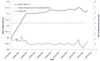
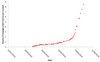
The lake behind the Attabad landslide, Gojal Lake, started to fill soon after the landslide occurred. From an early stage this lake was monitored by the geological team from FHA, providing an excellent dataset of the lake level against time. The filling curve is complex as a result of the hydro-meteorological regime. At the time of the landslide the river discharge was low. This increased during the late spring, fed primarily by snowmelt and the release of water from the local glaciers. Unfortunately gauging data is not available for the river upstream of the landslide.
Overtopping scenarios
As the lake level rose at Attabad, concern rapidly developed about the likely performance of the landslide mass during overtopping. Understanding of the situation was greatly hindered by a lack of knowledge of the structure of the landslide mass. The surface of the landslide at the saddle consisted of the lake deposit, which was easily erodible. However, the structure beneath this deposit was unclear, and no drilling was undertaken to determine the characteristics. A number of aspects suggested that the level of hazard was high, including the known performance of previous landslide barriers on the Hunza in which rapid breaching had been observed; the source materials for the landslide which were mostly comparatively fine grained deposits from glacial and previous mass movement events; and the fine grained nature of the surface of the landslide mass. Mitigating against a rapid breach event was the relatively low-angled downstream face of the landslide deposit and the potential for a coarse-grained core to the landslide.
The initial response to the crisis from the National Disaster Management Agency (NDMA) was to implement the construction of a spillway across the saddle of the landslide. This was originally intended to be 30m deep at the point of overtopping, although in the event the maximum depth achieved was about half of this. The second, rather later, response was to evacuate the population downstream of the barrier over a distance of about 100km, and to prepare evacuation plans for the remainder of the population along the Hunza and Indus rivers.
Generating overtopping scenarios proved to be very difficult given the lack of data for the area affected. Regression-type analyses for a breach event suggested that the peak discharge could range from about 5000 to 50,000m3/sec. Flood modelling, undertaken by several groups, suggested peak water depths of over 30m for reasonable breach scenarios. Previous landslide dam flood events suggested that little attenuation of the flood wave along the river valley was likely, generating high levels of risk along the length of the Hunza and Indus rivers.
Lake filling
Forecasting the time of overtopping proved to be very difficult for three key reasons:
1. The Hunza River has a very strong seasonal discharge, controlled primarily by snowmelt . Thus, the rate of in-flow was expected to increase substantially in the late spring. However, as this is temperature controlled, the timing of this increase proved difficult to estimate. Although in the event some increase in discharge did occur, this was less than had been anticipated, such that the overtopping event was rather later than some estimates had suggested.
2. Good quality topographic data were not available, meaning that determining the potential lake storage volume proved to be difficult.
3. The base of the spillway underwent heave as the lake level rose, probably in response to both increased water content in the silt and creep of the channel wall materials as they became wetter and/or as a result of loading of the sides of the channel with excavated materials. A series of unfortunately premature estimates of the overtopping date were made by a range of agencies, generating mistrust amongst the population. In an attempt to mitigate the uncertainty in terms of the overtopping date, daily graphs of water level against the spillway height were produced and posted online on a dedicated website by the combined FHA and Durham teams, showing the freeboard reduction with time, and a commentary was provided to explain how and why this was changing. The graphs were widely used in Pakistan, and provided an independent source of information to planners, NGOs and potential victims of a flood. However, the difficulties in monitoring the situation on the ground, especially in the later stages of the lake filling, meant that the heave of the channel base was under-estimated. As a result, the overtopping event occurred a few days later than had been anticipated.
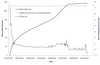
Early on seepage was identified as a potential cause of dam failure, although the morphology of the dam and the presence of the lake deposit were considered to reduce the likelihood of this type of collapse. Seepage first developed about two months after landslide emplacement, and steadily increased as the lake level rose. In all, seepage occurred in six locations on the downstream face of the dam, with the rate of flow increasing non-linearly with time. Whilst for a time the rapid increase in the seepage rate caused concern, it did not induce failure of the dam prior to overtopping as had been feared.
Overtopping
Initial overtopping, in form of flow through the spillway, occurred on the night of 28-29 May 2010, at an elevation of 111.41m above the valley floor. At the time of overtopping the spillway was about 1m wide at the base and was unlined, and the lake had reached a length of about 21km and had an estimated volume of 450-500Mm3. By this time the lake had inundated several villages, including 171 residential properties, and it had flooded 25km of the Karakoram Highway, including several important bridges. Unfortunately, throughout the crisis rockfalls continued to occur from the scar of the Attabad landslide. Three people have been killed and another seriously injured to date by rockfall events in this area.
Behaviour after overtopping
After initial overtopping water flow through the spillway increased slowly at first, during which the lake level continued to increase at an initial rate of about a metre every two days. The downstream portion of the channel suffered substantial, rapid headward erosion, but downcutting of the channel bed remained limited. After a period of about six days, on 5 June 2010, the outflow first equilibrated with inflow, by which time the lake level had risen by a further 3.81m. Thereafter the lake level rose and fell slightly according to changes in inflow rate. Headward erosion and downcutting was controlled at the saddle by the presence of boulders beneath the streambed. Thereafter the dam remained stable, with slow natural widening of the channel but surprisingly little downward erosion. The reasons for this remain unclear, but it is likely that the bed of the channel is being protected by boulders or rock slabs. The extreme monsoon rainfall experienced across much of Pakistan in July and August 2010 did not penetrate as far north as Attabad, such that the dam was unaffected.
The stabilisation of the lake flow created a serious management challenge for the authorities, in part because, despite advice to the contrary, no clear protocol was established that would allow the all clear to be sounded. As a result, the displaced population remained in camps for all of the summer, living in very difficult conditions. Frustrations grew rapidly, leading to some pre-emptive action by local villagers to try to widen the spillway by hand. At the end of the summer the lake level fell by about 2m as inflow reduced, leaving the spillway intact.
Future management
Although still intact, the Attabad landslide dam continues to represent a serious hazard management problem in Pakistan. It is unsurprising that in the aftermath of the disastrous floods across Pakistan in the summer of 2010 attention shifted away from Attabad, but unfortunately the problem is unresolved. Forecasting of future behaviour remains difficult, but the following scenarios could be considered:
• The dam may remain intact in the long term, during which it will progressively fill with sediment. This would be a surprising outcome given the lack of evidence of longevity of other landslide dams on the Hunza, but it cannot be discounted.
• The dam may fail through overtopping in a future large snowmelt or rainfall event. In 2005 another large landslide dam formed near Hattian Bala in Kashmir as a result of an earthquake. Overtopping occurred in 2006 but the dam remained stable until February 2010, when it breached rapidly in a rainstorm.
• The dam may fail through overtopping as a result of a large glacial lake outburst flood (GLOF). Such events are common but unpredictable on the Hunza River. This creates the scenario of a combined landslide breach and GLOF discharge event downstream.
• The dam could fail through a further landslide into the lake. Such an event is highly unpredictable.
• The dam could fail in a large earthquake. This area is close to a major fault system and is considered to have high levels of seismic risk. Such an event is utterly unpredictable.
A number of other scenarios are possible too, but are considered to be less likely. Thus, there is little doubt that the level of hazard associated with the Attabad landslide is unacceptably high, and to this end the Pakistan Government is planning to attempt to deepen the spillway by 30m during the winter low flow period. At the time of writing preparatory work has started, but deepening the spillway has not begun.
Lessons for future landslide events
The Attabad landslide event challenged the capabilities of all concerned. Whilst there are many lessons to be learnt, the following are particularly pertinent:
• The lack of investigation of the landslide mass meant that behaviour forecasting was very difficult. This must be a priority when such events occur.
• Disaster management plans must have clear protocols to allow decisions to be made about when the hazard has diminished to the extent of being tolerable.
• Proper, real time monitoring of all the key parameters controlling overtopping is essential.
• Clear, reliable communication channels that allow dissemination of good quality information to the public are required.
• Further research is needed to improve our understanding of breach dynamics and outburst floods.
Unfortunately, in the aftermath of the landslide further sites in Gilgit - Baltistan have started to become a cause for concern. For example at Miachar in Nagar, 10km downstream from Attabad, a new set of large cracks have started to develop in a slope that is occupied by 380 households. The potential for a large landslide is clear, although to date no evaluation has been undertaken of the site. Unfortunately, the current hazard in Hunza is far from over and new ones may be on the horizon.
Professor David Petley, Wilson Professor of Hazard and Risk, and Executive Director, Institute of Hazard and Risk, Durham University, Durham DH1 3LE, UK. Email: d.n.petley@durham.ac.uk