A research team led by National Chung Hsing University (NCHU) has carried out a large-scale physical model experiment to examine the failure of the Matai’an River landslide dam, the largest recorded in Taiwan, in an effort to improve prediction and response to similar hazards.
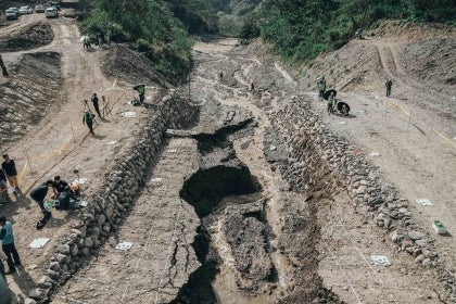
The experiment took place on April 20, 2026, at a dedicated field site in Huisun Forest in central Taiwan, where researchers reconstructed the full sequence of dam formation, impoundment and breach using a 1:50 scale model. The work was commissioned by Taiwan’s Forestry and Nature Conservation Agency following the 2025 event in Hualien County, where a massive slope collapse blocked the Matai’an River.
The original landslide dam reached an estimated height of 200m and a volume of about 200 million cubic metres. Due to the remote mountainous location, direct observations during the initial breach phase were limited, leaving gaps in understanding of how failure progressed and how peak flows developed downstream.
To address this, the NCHU team used a purpose-built experimental site on Landao Creek in Huisun Forest, located in Nantou County. Developed over more than a decade, the facility integrates a discharge control system linked to the Nenggao Canal, allowing researchers to regulate inflows and simulate flood conditions under controlled and repeatable settings. Instrumentation includes high-resolution topographic surveys, synchronized video recording and continuous water-level monitoring, enabling detailed observation of large-scale landslide-dam processes.
During the test, researchers applied what they describe as a “4D spatiotemporal synchronous observation framework,” combining multiple measurement systems to capture changes over time and space. Data collected included water levels and flow velocities, breach formation and expansion, sediment transport, upstream and downstream channel evolution, subsurface scouring, pore-water pressure and associated seismic signals.
The project was conducted in collaboration with National Yang Ming Chiao Tung University and National Cheng Kung University, with support from the Rural Development and Soil and Water Conservation Agency. More than 60 personnel and several units of heavy equipment were mobilised over months of preparation, making it one of the largest experiments of its kind.
International experts, including Japanese sabo specialists, attended the test alongside engineers and members of the public. Organisers said the event also aimed to strengthen risk communication and awareness of landslide dam hazards.
According to the research team, the results will be used to refine estimates of breach timing and peak discharge, key parameters for evacuation planning and emergency response. The findings are also expected to support the development of early warning systems and improve watershed-scale disaster management.
Taiwan’s steep terrain and exposure to intense rainfall events make it particularly vulnerable to landslide dams and related flooding. Researchers say further analysis is ongoing, with the aim of integrating the results into national hazard mitigation strategies and contributing to international research on sediment-related disasters.