Head above water - studying flood risk
24 July 2006Cees-Jan van Westen describes some coastal engineering projects in the Netherlands, and reports on a study carried out to assess flood risks in the country
For various reasons, people have always felt attracted to coastal areas. In particular, to those areas where rivers flow into the sea and form deltas. They present ideal conditions to establish all kinds of activities. Some of the traces left from the past show that man came here to hunt, fish and, later, to cultivate the soil.
Through the centuries, hydraulic structures have been built in order to combat the ceaseless attacks of the sea on the coast. However, the construction of these dams, dikes and other structures has changed the nature of these delta areas, as discussed in the following paper.
Ecological values
A few decades ago, the impact on flora, fauna, soil and climate was hardly considered in the decision-making process when building dams. However, this has now changed. Ecology plays an increasingly important role in the preparation, construction and management of hydraulic engineering structures. The value of the coastal area is determined, to a great extent, by three distinct processes. These are:
•Delta areas possess a largely self-purifying mechanism, which can greatly reduce the effects of surface-water pollution. Organic matter transported by the river is, to a great extent, rendered harmless.
•The fresh water, transported by the rivers, mixes with the salt seawater in the estuaries. Thus, a fresh-water gradient is brought about, the extent of which will depend upon the rate of river-supply and the size of the estuary. As a result, one will find vegetation that flourishes on brackish mudflats inland whereas a halophile vegetation is found towards the sea. This process stimulates the diversity of the ecosystem in other ways.
•The sea and rivers often transport large quantities of sand and silt to and from the estuary. These substances settle in the deltas. During the centuries, islands are created in this manner and, even today, this maintains the system of shoals, mudflats and salt-marshes.
Coastal engineering projects
Safety has always been the primary reason for the building of hydraulic structures such as dams in coastal areas like the Netherlands. The population has always needed to protect itself and its goods against the sea by building dikes and sealing off the estuaries.
Although safety has been the primary reason for building coastal defences, there were also other factors. One of them has been the acquisition of land for agricultural needs.
In order to combat the salination of agricultural and horticultural soil and to improve the entire water management in the area, discharge-sluices have been built in the mouth of many Dutch rivers, allowing the discharge of those rivers to be regulated.
On all fronts, human and technological intervention in delta areas causes many changes. The implementation of a project often has distinct impacts on the delta areas. Examples, including some specific instances in the Netherlands, include:
•Transformation: in the delta areas, sedimentation and erosion occur which change the pattern of the river-branches continuously. Human intervention can put an end to these natural processes. The shape of the delta area in the southwestern part of the Netherlands for instance has been strongly influenced by the building of dikes.
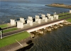
•Closure: throughout the world, deltas have been permanently sealed off from the sea by dams. After a closure, depending upon the management, the waters in a former estuary can become: fresh, as in the Zuyderzee; brackish, as in the Veerse Meer; or saline, as in the Grevelingenmeer. There are 11 embankment dams in the Netherlands meeting the icold criterion for large dams. From these dams 10 were built for flood protection, while one circular dam provides controlled storage of contaminated soil (see table 1).
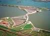
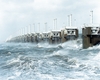
•Reduction of the tidal action: a total closure results in the disappearance of tidal action. In a number of rivers, however, a hydraulic engineering structure in the mouth has only reduced the tidal action. One example of this is the storm-surge barrier in the Eastern Scheldt (shown in the photograph).
•Permanent exposure: after an estuary has been sealed off, areas of land that hitherto were submerged regularly may be exposed permanently. These often fertile lands can be used for agricultural purposes but also as a natural or recreational area (e.g. islands in the Grevelingenmeer).
•Reclamation: Large areas have been reclaimed from the sea for agriculture (the IJsselmeerpolders), for industry (the Maasvlakte near Rotterdam) and for transport.
•Dredging: to further the interests of trade and shipping, many rivers and delta areas have been modified. An instance forms the Western Scheldt, which is being dredged continuously.
•Pollution: as a result of human action, coastal areas have often been polluted by industrial waste, pesticides and heavy metals. Examples of this are: the Rhine, the Western Scheldt in Belgium and the Netherlands and the Wadden sea in The Netherlands, Germany and Denmark.
Usually, however, the deltas suffer most from the direct consequences of hydraulic engineering structures. Closure is followed often by desalination and important functions and characteristics of the prevailing ecosystem quickly disappear.
Dutch hydro development
The present
Many rivers and estuaries have been changed by building dams for hydro power, but not in the Netherlands. Because of the flat topography, the role of hydro power has always been very modest.
The gross theoretical hydro power potential of the Netherlands is only 700GWh/yr, the technically feasible potential is 200GWh/yr and the economically feasible potential is 130GWh/yr. All hydro power plants of the country are run-of-river schemes, developed at existing weirs in rivers.
There are a total of six hydro power plants in operation, with an installed hydro capacity of 37.6MW. There are three hydro plants with individual capacities of 10MW or greater, and there is 1.8MW of hydro capacity at units more than 40 years old.
Energy production by hydro plants depends mainly on the runoff regime of the main rivers (Rhine and Meuse). In 2003, hydro plants generated 72GWh (only 0.1% of national electricity).
The theoretical hydro power potential of The Netherlands is equivalent to about 1300MW and the technical feasible potential ranges from 80 to 110MW. However, the production cost of hydro is unfavourable when compared to thermal power. The government would like to promote the development of renewable energy with tax concessions, which might change the situation slightly.
Theoretically, tidal power may be generated in the southwest part of the country. Large scale tidal power, however, would have a negative impact on the ecology of the delta area.
The future
In 1993, an agreement with the Norwegian company SørKraft was signed for the supply of 1200MW through DC undersea cables. By day, hydro power from Norway would be supplied to the Netherlands, while during the night the Dutch electrical surplus power would be used for Norwegian pumped storage. Having been suspended for many years, this project was reactivated recently. The updated project implies a 580km long cable for a capacity of 600MW, and is scheduled for release in 2008.
A new approach to flood protection
It is important to clearly identify which consequences flooding in a particular area will bring. This is very important because the consequences may vary from one dike ring area to another due to the layout and land use. When determining these consequences the following are taken into account:
•The scale of the flooding.
•The water depth.
•The flow velocity.
•The speed at which the water level in the dike ring area is rising and its effects.
A new method has been applied in the Netherlands for determining the probability of flooding. The essence of the method is that various ‘failure mechanisms’ can also initiate flooding: not just very high water levels, but also instability of a dike or failure to close a barrier on time. Any failure mechanism carries a risk of flooding. The probability of all failure mechanisms together determines the risk of flooding in a dike ring area.
Once the consequences have been identified they can then be combined with the calculated probability for dike ring areas. In this way the flooding risk can be determined for each dike ring area.
Area 14 Zuid-Holland
Dike ring 14, Zuid-Holland, is situated in the provinces of North Holland, South Holland and Utrecht. To the west the area is protected from the North Sea by dunes. In several places in these dunes there are solid defences such as the dune base reinforcement at Ter Heijde, the beach foot reinforcement at Scheveningen and the dike at Katwijk, all three of them near The Hague. On the north side the area is bordered by the Noordzeekanaal, on the south side by the Nieuwe Waterweg, the Nieuwe Maas and the Hollandsche IJssel and on the east side by the Amsterdam Rijnkanaal. The area is approximately 223,000ha. According to the Flood Defences Act the dike ring area has an average exceedance probability of 1/10,000 per year.
The elevation in dike ring 14 varies widely. The height of the coastal strip is mean sea level (MSL) +0m. The elevation of the Alexanderpolder, just to the north of Rotterdam, is lower than MSL –6m in some areas. The Haarlemmermeerpolder too, where Schiphol Airport is situated, is lower than MSL –5m.
The dike ring area has approximately 3.2M inhabitants. The major residential towns in the area are Amsterdam, Rotterdam, The Hague, Haarlem, Leiden and Delft. There is also a lot of industry present in this dike ring.
Results, risks, consequences and probabilities
For dike ring area 14 the consequences were calculated with both the global method and the detailed method. The economic risk for dike ring area 14 was calculated as US$2.9M per year. The economic damage amounts to between US$353.6M and US$46.8B, depending of the location of the breach. The victim risk depends on the location of the breach and varies from 0.012 to 2.44 per year.
The upper limit is based on an unexpected flood in which no evacuation takes place. The lower limit is based on a predictable inundation in which an organised evacuation occurs.
In the case of South Holland the breach would be most likely to occur in the coast. The situation at sea cannot generally be predicted more than a day in advance and this does not allow sufficient time for a full evacuation of the threatened area. Particularly with multiple breaches from the coast, large areas with many inhabitants could be inundated. The damage and the number of victims will greatly depend on the breach scenario, which will determine the area flooded and the characteristics of the flooding as well as whether evacuation is possible. Obstacles in the dike ring, such as secondary flood defences and old dikes, can prevent large areas of the dike ring from flooding.
The calculations resulted in a probability of flooding of 1/2500 per year for dike ring 14 – a relatively small probability.
Investigation into weak locations
The main weak locations are the Scheveningen promenade where 'dune erosion' is involved and a dike section with uplifting and piping. There is also another weak location due to 'dune erosion' and two other weak hydraulic structures involving the 'not-closing' mechanism. The dike manager acknowledged this.
With further investigation and strengthening measures if necessary for the two main weak locations the probability of flooding can be reduced to 1/5000 per year. An upper limit for the cost of extending the seepage length is US$4.7M. The basic principle here is that the entire dike section is tackled, even where the problem may not be involved.
The costs of tackling the dune erosion at the other main weak location still has to be added to this: for the two other weak hydraulic structures where 'not-closing' is a factor, this can be adequately dealt with by taking procedural measures. This does not involve any significant investment costs, although the probability of flooding after taking the procedural measures may be further reduced to 1/7000 per year. The economic risk amounts to US1.01M/yr and the victim risk varies, depending on the location of the breach, from 0.004 to 0.9 per year.
Findings
A new diagnosis instrument was used during the study. This enabled the stability of dikes and engineering works as well as their height to be looked at in more detail. From this study it appears that it is not the height of the dikes but rather water seepage under the dike which is a real threat. In practice, in such an event a water board would take emergency measures. The areas vulnerable to this phenomenon have now been surveyed. Because there are still many uncertainties surrounding the calculations, further research is required. For engineering works such as locks, in some cases it appeared that the closing procedures were not adequate. This has now been addressed.
During the study considerable attention was given to calculating the actual flood risk in relation to the consequences of flooding. This differs from the current method used in which the probability of exceeding a statistically determined high water level is considered indicative of safety.
Sixteen of the 53 dike rings in the Netherlands were investigated. This selection was considered representative of the country as a whole. Detailed risk calculations were carried out for three of them: the Noordoostpolder (Central part), Zuid Holland and Land van Heusden/De Maaskant (Southern part).
The added value of the method is that vulnerable locations can be identified and insight into the significance of these locations is provided in terms of the consequences of flooding. When the method is applied nationwide improvements to the flood defences can be prioritised more effectively.
Further research
All those involved share the view that the method used offers added value. The calculations provide the most realistic picture of the probability of flooding based on current understanding. The calculated probability of flooding, however, is not yet robust enough for these figures to be considered absolute values. Further research and development of the method could help to make the method more robust in the future.
For most applications the picture of the flood risks nationwide needs to be completed. Therefore it is recommended that the method also be applied to the remaining 37 dike ring areas. To obtain a proper estimate of the consequences a detailed method needs to be used for all dike ring areas. More attention should also be focused on how cost/benefit analyses can be carried out to deal with relatively weak locations.
Author Info:
Cees-Jan van Westen, Senior Advisor, Ministry of Public Works, Transport and Water Management, Rijkswaterstaat, Holland. Email: c.j.vwesten@dww.rws.minvenw.nl
TablesTable 1