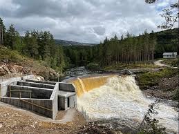
Elwha dam, constructed during the period 1910-13, is a 32m high concrete gravity dam that forms Lake Aldwell 12.9km upstream from the river’s mouth. Glines Canyon dam, built in 1927, is a 64m high concrete arch dam that forms Lake Mills 21km upstream from the river’s mouth.
When the dams were first built, they were significant producers of electricity on the Olympic Peninsula. Today, the dams are operated in run-of-river mode and generate about 40% of the electricity needs for the Diashowa America paper mill in Port Angeles, Washington. These two dams have no facilities for the upstream passage of anadromous fish and their removal would provide an opportunity to restore an entire watershed to near natural conditions.
In 2000, the US Department of the Interior purchased the Elwha and Glines Canyon dams in preparation for their removal. One of the major challenges in removing these two dams is the management of nearly 13.8Mm3 of sediment trapped within the two reservoirs. Of this total sediment volume, 10.8Mm3 is trapped behind Glines Canyon dam in Lake Mills and 3.8Mm3 is trapped behind Elwha dam in Lake Aldwell. About one half of the sediments in Lake Mills is coarse grained (sand, gravel, and cobble-sized) and the remaining half is fine grained (clay and silt-sized). Some of the fine-grained sediments are transported through the reservoirs while the remainder is deposited along the reservoir bottoms. All of the coarse-grained sediments are trapped within the reservoirs as delta deposits located at the upstream end of each reservoir.
Studies carried out by the US Bureau of Reclamation and USACE has provided critical data for a new sediment erosion model and helped lead to the conclusion that the reservoir sediment erosion could be managed by controlling the rate of reservoir drawdown and that not all of the sediments would be eroded from the reservoir.
The new reservoir sediment erosion model was an empirically based mass balanced model. This model predicted the rates and final quantities of fine and coarse-grained sediments eroded from each reservoir. The standard HEC-6 model of USACE was applied, using measured cross sections of the downstream river channels, to predict the potential for sediment deposition. The selected plan for managing the 13.8Mm3 of reservoir sediment is to remove both dams, in controlled increments, over a two-year period. Rates of sediment erosion, transport, and deposition are to be intensively monitored during dam removal. These rates will be monitored to determine if they match the predicted values within acceptable limits before proceeding with the next increment of dam removal.


