

Ensuring the safety and performance of hydropower and multipurpose dams requires both reliable technical information and robust governance frameworks. Recent publications from India and Japan illustrate how these elements are being addressed in different national contexts. In India, researchers have developed a comprehensive, open-access dataset describing physical, climatic, and human-influenced characteristics of more than 5,700 dam catchments, providing a consistent foundation for hydrological and dam safety analysis. In Japan, a World Bank report documents the legal, institutional, and operational systems that underpin dam safety management across a large and diverse portfolio of dams operating under complex natural and social conditions. Together, the two reports provide complementary perspectives on the role of data and governance in dam safety practice.
National-scale dataset in India
India hosts one of the world’s largest and most diverse portfolios of dam infrastructure, supporting irrigation, hydropower generation, flood management, water supply, and regional development. The scale and complexity of this infrastructure places significant demands on dam safety assessment, hydrological analysis, and long-term operational planning. Recognising the need for consistent, catchment-scale information to support these activities, Tiwari and Aadhar (2025) have developed a comprehensive, open-access dataset describing physical, climatic, and anthropogenic attributes for dam catchments across the Indian subcontinent. The dataset, referred to as DAM-IN, covers 5715 dam catchments across 18 river basins and brings together more than 45 attributes derived from observed data, reanalysis products, and remote sensing sources.
Published in Scientific Data, the study provides a structured description of how the dataset was assembled, validated, and made available for use by engineers, researchers, and water agencies. Rather than evaluating dam performance or safety directly, the work focuses on assembling the foundational data required for hydrological, hydraulic, environmental, and dam safety studies at a national scale.
The authors note that while several global and regional dam databases exist, such as Global Dam Watch and the Global Dam Tracker, these resources primarily focus on dam location, physical dimensions, reservoir capacity, and construction history. They generally do not provide the full range of catchment-level attributes required to analyse inflows, flood behaviour, sediment dynamics, or interactions between climate, land use, and hydrology.
In India, these information gaps are particularly significant. The country has experienced increased variability in monsoon rainfall and a rise in hydrological extremes over recent decades. According to figures cited from the Central Water Commission, hydrological extremes account for a substantial proportion of dam failure cases. Against this backdrop, the authors emphasise the need for datasets that characterise not only the dam structure itself but also the upstream catchment conditions that influence reservoir inflows and flood risk. The DAM-IN dataset addresses this requirement by providing harmonised catchment attributes grouped into six broad categories: topography, geology and groundwater, soil, land use and land cover (LULC) and vegetation, climate, and human-induced activities.
Dam inventory
The dataset includes 5715 dams distributed across 18 major river basins in India. Dam locations were sourced from the National Register of Large Dams (NRLD, 2019). Using these locations as outlet points, the authors delineated upstream catchments for each dam using a 30m resolution Digital Elevation Model from the Shuttle Radar Topography Mission (SRTM).
Watershed delineation was carried out using the Automatic Outlet Relocation (AOR) algorithm implemented within ArcGIS. Prior to delineation, the elevation data were pre-processed to remove sinks and artefacts that could distort flow routing. The authors selected the AOR approach to improve consistency and reduce errors associated with manual outlet placement, particularly at a national scale. The delineated catchments form the spatial basis for all subsequent attribute calculations.
Seven topographic attributes were derived for each dam catchment: mean elevation, minimum elevation, maximum elevation, mean slope, catchment area, perimeter, and circularity ratio. These parameters were calculated directly from the SRTM DEM using standard spatial analysis tools. The authors report substantial spatial variability across the dataset. Mean catchment elevations range from approximately 25m to around 1000m asl. Slopes are generally lower in central India and higher in coastal and northern regions. Most dam catchments are relatively small, with the majority covering less than 500km2. Only around 15% of catchments exceed this area threshold.
The circularity ratio, used to describe catchment shape, indicates that most dam catchments in India are elongated rather than compact. According to the authors, these topographic characteristics are relevant for understanding runoff response, sediment transport, and flood hydrograph behaviour, although the dataset itself does not attempt to model these processes.
Geological, groundwater and soil attributes
To characterise subsurface conditions, the dataset includes geological and hydrogeological attributes derived from global datasets. Dominant lithological class for each catchment was identified using the Global Lithological Map (GLiM), focusing on first-level lithological classifications. Ten dominant lithological classes are represented across Indian dam catchments, including basic volcanic rocks, mixed sedimentary rocks, unconsolidated sediments, metamorphic rocks, and carbonate sedimentary rocks. These classifications provide a broad indication of bedrock type and its influence on hydrological behaviour.
Subsurface permeability and porosity were estimated using the Global Hydrogeology Maps (GLHYMPS) dataset. Area-weighted averages were calculated for each catchment. These attributes describe the capacity of subsurface materials to transmit and store water, which is relevant for groundwater–surface water interactions and baseflow contributions. In addition, mean groundwater depth was estimated using data from more than 4900 monitoring wells maintained by the Central Ground Water Board, accessed through the India-WRIS platform. Groundwater data cover the period from 1996 to 2020. Where no wells were present within a catchment, the nearest available observation was used. The dataset records considerable regional variability, with many central Indian catchments exhibiting shallow groundwater levels, while deeper groundwater tables are more common in parts of southern and western India.
Eight soil attributes were compiled for each dam catchment: soil texture fractions (sand, silt, clay, and coarse fragments), organic carbon content, available water capacity, saturated hydraulic conductivity, porosity, bulk density, and maximum water content.
These attributes were derived primarily from the Harmonised World Soil Database (HWSD) and supplementary FAO soil datasets. Because soil properties vary with depth, the authors calculated weighted averages to represent conditions down to 200cm.
Spatial patterns show that clay- and silt-rich soils are common in many regions and are generally associated with higher porosity and conductivity values, while bulk density tends to vary inversely with porosity. The authors present these relationships descriptively, without drawing conclusions about hydrological performance or suitability for specific dam types .
Land use, land cover and vegetation
Land use and land cover attributes were derived from datasets produced by India’s National Remote Sensing Centre at 56m resolution for the 2015–2016 period. The original classifications were reclassified into five primary categories: built-up areas, agriculture, forest, scrubland, and water bodies. For each catchment, the dataset records the dominant LULC class as well as the fractional area of each category. Agriculture is identified as the dominant land cover in the majority of dam catchments, followed by forest and scrubland.
To capture seasonal vegetation dynamics, the dataset also includes Normalised Difference Vegetation Index (NDVI) values for four climatological seasons: December–February, March–May, June–August, and September–November. NDVI data were derived from AVHRR satellite products covering the period 1981–2020 and resampled to a coarser resolution for consistency.
Seasonal NDVI patterns show higher vegetation density during and following the monsoon period, particularly in September–November and December–February. The dataset presents these values as descriptive indicators of vegetation cover rather than as inputs to specific ecological or hydrological models
Climatic attributes and dam safety
Climatic information is a major component of the DAM-IN dataset. Daily, area-averaged time series were generated for precipitation, minimum and maximum temperature, wind speed, actual evapotranspiration, and potential evapotranspiration for each catchment over the period 1951–2019. Precipitation and temperature data were sourced from the India Meteorological Department for areas within India and from the ERA5 reanalysis dataset for regions outside national boundaries. Potential evapotranspiration was estimated using the Hargreaves–Samani method, based on temperature and radiation data. In addition to mean values, the dataset includes derived climatic indicators such as aridity index, precipitation seasonality, maximum daily precipitation, and the frequency and duration of high- and low-precipitation events. These metrics were calculated following established definitions used in climate variability and hydrological studies.
The authors report strong spatial variability across the country. For example, dam catchments in the Western Ghats receive substantially higher mean rainfall than those in parts of Gujarat and leeward regions. Seasonality indices indicate that most precipitation occurs within a limited number of months, reflecting the dominance of the southwest monsoon.
Human-induced activities
To represent anthropogenic pressures within dam catchments, the dataset includes four indicators: road density, human footprint, night-time light intensity, and population count. Road density data were obtained from the Global Roads Inventory Project, while human footprint values were sourced from the Global Human Footprint dataset. Night-time light intensity was derived from the DMSP-OLS satellite products, using stable light composites. Population counts were taken from the Gridded Population of the World dataset for the year 2020. These indicators show that many dam catchments experience moderate levels of infrastructure and human activity, although population density and night-time light values remain low in a large proportion of catchments. The authors note that global datasets were used for some indicators due to the lack of consistent regional alternatives, and they acknowledge that this may introduce uncertainty.
Data access and intended use
The complete DAM-IN dataset is hosted on Zenodo and is organised by river basin and individual dam catchment. Each catchment folder contains static attributes and time-series data in standard formats. The authors also provide code used to generate the dataset.
Validation was conducted through spatial comparison of derived attributes with source datasets to ensure consistency in regional patterns. The study does not include independent field validation or performance benchmarking. The authors state that the dataset is intended to support hydrological modelling, dam safety analysis, reservoir management studies, environmental assessments, and climate risk analysis. They emphasise that while the dataset enables such work, it does not itself evaluate dam safety or operational adequacy.
The DAM-IN dataset represents a national-scale effort to consolidate diverse geospatial and temporal information relevant to dam catchments in India. By integrating topographic, geological, soil, land use, climatic, and anthropogenic attributes into a single, open-access resource, the study provides a data foundation for future analysis rather than prescriptive conclusions.
For the international hydropower and dam safety community, the dataset offers a detailed example of how large-scale catchment characterisation can be assembled using existing data sources. Its value lies in standardisation, transparency, and accessibility, while its limitations – particularly those related to data resolution and source consistency – are clearly acknowledged by the authors. While the DAM-IN dataset focuses on assembling consistent, catchment-scale information to support hydrological, environmental, and dam safety studies in India, it also highlights the broader context in which such data are applied. The use of detailed physical, climatic, and anthropogenic attributes becomes most relevant when embedded within established regulatory, institutional, and operational frameworks.
Dam safety management in Japan
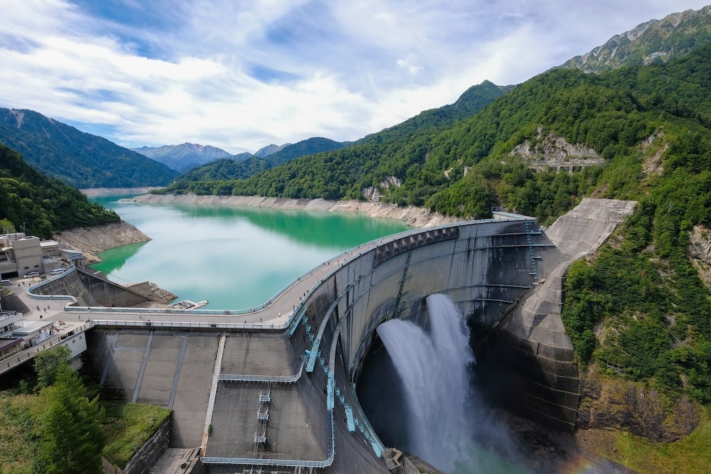
Japan has developed one of the most comprehensive dam safety management systems in the world, shaped by a combination of challenging natural conditions, dense downstream populations, and a long history of water infrastructure development. The World Bank report Dam Safety Management in Japan (2025) documents the country’s legal, regulatory, institutional, and operational approaches to dam safety, with the objective of sharing practices and lessons that may be relevant for other countries seeking to strengthen their own dam safety assurance systems.
The report does not present a prescriptive model but instead describes how Japan’s system has evolved over time in response to floods, earthquakes, water scarcity, and changing socioeconomic conditions. It situates dam safety within a broader framework of integrated water resources management, emergency preparedness, and public safety. Japan has more than 3100 large dams, defined as dams with a height of 15m or more, or dams between 5 and 15m that impound more than 3 million m3 of water. This places Japan fourth globally by number of large dams, after China, the US, and India. In addition to large dams, Japan has more than 150,000 irrigation ponds, of which approximately 61,000 serve irrigation areas larger than 2 ha. Around 70% of these ponds were constructed during the Edo period (1603–1868) or earlier, before modern regulatory frameworks.
The majority of large dams in Japan are irrigation and multipurpose dams, followed by hydro dams. In terms of structural type, concrete gravity and earthfill dams dominate, with rockfill and arch dams also widely used.
Natural and socioeconomic context
The report emphasises that Japan’s dam safety framework cannot be separated from its natural and human geography. Approximately 70% of the country’s land area is mountainous or hilly, resulting in rivers that are generally short, steep, and prone to rapid flow. These characteristics increase flood risk and complicate reservoir operation and sediment management. Japan is also located on the Circum-Pacific seismic belt. According to data cited in the report, around 20% of the world’s earthquakes with a magnitude greater than 6 occur in or around Japan. In addition, the country experiences heavy rainfall associated with monsoon systems, seasonal rain fronts, and typhoons. Large metropolitan areas, including Tokyo, Osaka, and Nagoya, are located on floodplains downstream of major river systems and account for a high proportion of the national population and fixed assets.
These conditions have driven the development of stringent design standards, operational rules, and emergency management practices for dams..
Historical development of dams
The construction of dams in Japan spans more than two millennia. Early dams and ponds were primarily built for irrigation to support agricultural production. Hydropower dams expanded rapidly in the 1950s and 1960s to meet rising electricity demand during postwar industrialisation. From the 1960s onwards, multipurpose dams became more common, combining flood control, water supply, and hydropower generation. The report documents how the number of concrete dams increased significantly during this period, reflecting a policy preference for structures perceived as more robust against overtopping and variable river flows. Many of these developments were led by national government agencies, with later participation by prefectural governments and private hydropower operators. Flood control has been a central driver of dam development in Japan. The report presents historical data showing a substantial reduction in flood-related casualties and economic losses from the 1960s onwards, coinciding with the expansion of multipurpose dams and river improvement works.
Dams have also become increasingly important for domestic and industrial water supply. According to the report, the share of domestic water supplied by dams increased from 11% in 1965 to 48% in 2020. This reflects both rising demand and the need to buffer seasonal variability in river flows. In major metropolitan regions such as the Tokyo area, extensive systems of dams and bulk water conveyance infrastructure have been developed to ensure reliable supply
Hydropower is a significant component of Japan’s energy system. As of 2024, total installed hydropower capacity, including pumped storage, was 49.66GW.
Japan has 650 hydropower dams, including both single-purpose and multipurpose facilities. The country also has the second-largest pumped storage capacity in the world, with 42 pumped storage plants capable of absorbing and discharging approximately 27GW of power. The report notes that Japan has been a technology leader in variable-speed pumped storage systems since the 1990s, enabling flexible integration of variable electricity demand and supply. Hydropower dams are owned and operated by private electric power companies, including regional utilities and wholesale generators. While ownership is private, dam safety obligations are governed by national laws and regulations.
Legal and institutional frameworks
The legal foundation for dam safety in Japan is anchored in the River Act, which establishes responsibilities for river administration, dam operation, and flood control. The report details how different dam purposes are governed by specific laws and administrative arrangements, while remaining integrated within a national framework.
Multiple ministries are involved in water resources and dam management. The Ministry of Land, Infrastructure, Transport and Tourism (MLIT) plays a central coordinating role, particularly for river management, flood control, and multipurpose dams. The Ministry of Agriculture, Forestry and Fisheries oversees irrigation dams and ponds, while the Ministry of Economy, Trade and Industry is responsible for hydropower. Environmental aspects fall under the Ministry of the Environment. Institutional arrangements vary depending on dam purpose and river classification, but the report highlights the importance of clear allocation of responsibilities among dam owners, regulators, and operators. Legal accountability for dam safety rests with dam owners, regardless of ownership structure.
Design standards, O&M
Japan applies detailed technical standards for dam design, construction, and operation. These standards include rigorous seismic design requirements, reflecting the country’s high earthquake risk. The report describes how seismic performance has been evaluated and upgraded following major events, including the Great East Japan Earthquake of 2011 and the Noto Peninsula Earthquake of 2024. Operation and maintenance requirements are formalised through dam operation rules and manuals, which define normal, flood, and emergency operating conditions. These rules are legally binding and subject to regulatory oversight. The report also describes systematic dam inspection and monitoring practices, supported by dense hydrometeorological and seismic monitoring networks and advanced data management systems. A significant portion of the report focuses on the safety of existing dams, particularly older structures built before modern standards were introduced. While failures of large dams in Japan have been rare, the report documents a small number of historical incidents, most of which occurred prior to the establishment of the current regulatory framework.
Irrigation ponds present a distinct challenge due to their age, number, and dispersed ownership. The report notes that many ponds were constructed using older techniques and are located upstream of communities that have since urbanised. Following the failure of the Fujinuma-Ike irrigation pond during the 2011 earthquake, national and prefectural governments strengthened inspection, rehabilitation, and prioritisation programmes for irrigation ponds deemed to pose higher risks.
Emergency preparedness is a core element of Japan’s dam safety system. The report outlines procedures for emergency dam operation during extraordinary floods, including pre-flood reservoir drawdown where appropriate. These operations are coordinated with downstream river management and disaster response agencies. Public safety measures include flood warning systems, notification protocols for dam discharge, and the use of flood hazard maps.
Funding mechanisms
Funding for dam safety assurance varies by dam purpose and ownership. Multipurpose dams are typically funded through national and prefectural budgets, while hydropower dams are financed by private operators. The report also describes the use of contingency budgets for emergency repairs and rehabilitation, as well as financing mechanisms employed by the Japan Water Agency for large-scale water infrastructure.
Report conclusions
The World Bank report concludes that Japan’s dam safety management system has evolved through long-term investment in legal frameworks, technical standards, institutional capacity, and operational practice. The system reflects the country’s exposure to floods, earthquakes, and climate variability, as well as the high consequences of dam failure in densely populated downstream areas. Rather than presenting a single transferable model, the report documents how dam safety assurance in Japan is embedded within broader water resources management and disaster risk reduction policies. It provides detailed descriptions intended to inform further study and reflection by practitioners and policymakers in other national contexts.


