

New Zealand energy company Meridian was given cause for celebration when water levels of the country’s largest hydro storage lake, Lake Pūkaki, rose above average for the first time in months. Much missed rain from April to August, which finally arrived in September, meant the company’s hydro lakes were being managed extremely carefully.
As Meridian General Manager of Wholesale, Chris Ewers, said: There’s nothing like a helping hand from Mother Nature.”
Lake Pūkaki was below average for more than 150 days, and at historically low levels, before weeks of heavy rain and snowfall changed the outlook. During the beginning of October it rose 715mm to just over 525m above sea level – 102% of average for the time of year.
September rain exceeded expectations and the Waitaki catchment, which feeds Lake Pūkaki and the Waitaki Hydro Scheme, had its fourth wettest September on record. It’s not just water in the lakes that’s welcome though, as Ewers pointed out, in the mountains above the Waitaki catchment snow storage is now sitting at 117% of average.
“That’s great news for later in the season as the snow melts and feeds the lakes throughout the warmer months. After a challenging winter, we couldn’t have asked for a better start to spring,” he said.
On 20 August the snow base had been just 63% of average – the lowest recorded for that time of year, while it had been as low as 58% of average earlier in the season. Heavy snowfall soon saw snow storage in the Waitaki catchment rocket to 105% of average, up from 83% in mid-September.
Weather patterns
Recent research in New Zealand has also been investigating the impact of climate change on weather patterns. As Luke J Harrington et al acknowledge in Environmental Research Letters, understanding any changes in daily rainfall is particularly pertinent for a temperate, mid-latitude and topographically complex country like New Zealand, which relies primarily on rainfed pastoral agriculture and has a diverse array of rainfall regimes that differ significantly over short distances.
The researchers made use of thousands of regional climate modelling outputs from the Weather@Home project to resolve how the wettest and driest days of the year will respond to simulations of a 3°C world, relative to simulations of the climate of the recent past (2006–15).
With results projecting increases in the volatility and unevenness of daily rainfall across New Zealand, the research team says it’s further evidence of the challenges which must be confronted if global temperatures continue to increase rapidly over the twenty-first century.
WaterNSW
WaterNSW has rolled out an enhanced flood training programme for specialist dam operators at regional dam sites across Australia, significantly adding to the number of skilled personnel across multiple river valleys. Record numbers of WaterNSW dam operations and planning staff have recently completed training at Wyangala, Keepit, Copeton, Burrendong and Burrinjuck dams, gaining critical flood management skills at multiple locations.
The expanded training follows international awards in November last year recognising WaterNSW for innovation in the recruitment, retention and development of critical water management specialists whose functions include flood planning and response.
General Manager of Water Planning and Delivery, Ashley Webb, said the latest training introduced new staff to flood operations, and broadened the skills of existing team members to be familiar with multiple dams.
“WaterNSW crews are well-recognised as expert dam operators and we maintain that standard through selective recruiting and consistent training in this niche field,” he said. “Flood preparedness and response is critical to safeguarding our communities, protecting dam infrastructure and maintaining water security. Having a larger, well-prepared, regionally placed team means we have never been better placed to perform this key function.”
Although forecasts from the Bureau of Meteorology stated imminent flood risk is low for major WaterNSW regional supply dams, storage levels rose steadily on the back of periodic winter rainfall and wet catchments during October. The total regional average storage was approximately 80% of capacity, representing the highest dam levels seen since the end of the summer.
Following a recent seismic event, and in accordance with dam safety protocols, WaterNSW recently had to conduct assessments of three Hunter Valley dams on 23 August. A 4.8 magnitude earthquake was felt across the region but inspections at Glennies Creek, Glenbawn and Lostock dams confirmed no safety risk resulting from the event.
Meanwhile, in other news from WaterNSW, water has been released from Split Rock Dam to protect platypus on the Manilla and Namoi rivers, encouraging them to nest higher up the riverbanks.
As WaterNSW’s Ashley Webb explained, releasing some water in late winter-early spring, just before nesting season, means the higher river level will encourage platypus to build their nests further up the banks.
“Then if we need to do a bulk transfer of irrigation water later in the year from Split Rock to Keepit,” Webb said, “the water will slide past below the level of their nests, protecting the platypus and newborn puggles.”
A total of 7850 megalitres of water from Split Rock Dam was released over eight days from 26 August. This was captured and stored in Keepit Dam for use in the irrigation season from November to February.
Split Rock Dam has a capacity of 397,370 megalitres and is situated on the Manilla River. It was built in the 1980s to supplement supplies from Keepit Dam and meet increased agricultural demand for water in the Namoi Valley. With a capacity of 425,000 megalitres, Keepit Dam on the Namoi River was completed in 1960 and built to increase the availability of water for irrigation. This enabled increased agricultural production of cotton, lucerne, cereals, oilseed, wheat and vegetables in the region, driving the growth of downstream towns including Gunnedah, Narrabri, Wee Waa and Walgett.
Girl power in Australia
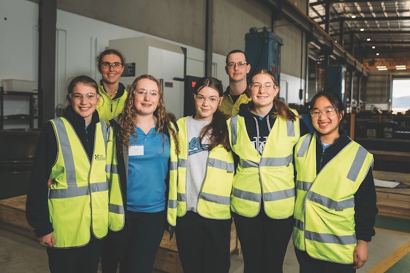
Students have participated in hands-on engineering and technology challenges at Hydro Tasmania’s Cambridge Workshop as part of its Girls in Power programme. The two-day workshop aims to engage young women in fun and immersive activities that inspire an interest in science, technology, engineering and mathematics (STEM).
Hydro Tasmania’s Executive General Manager of People, Culture and Engagement Ruth Groom said the programme was a fantastic opportunity to introduce young women to the possibility of a career in STEM.
“Women are still underrepresented in STEM industries including the renewable energy sector. We want to encourage more young women to take up STEM subjects in years 11 and 12 and consider careers in our sector when they graduate,” said Groom.
Girls make up only one quarter of year 12 enrolments in information technology, physics and engineering subjects, according to the Australian Government’s STEM Equity Monitor. The number of women enrolling in university STEM courses and working in STEM jobs has increased but only 37% of university STEM enrolments are from women, and women represent just 15% of all people working in STEM jobs.
The workshops saw 35 students participate in challenges that address real-world scenarios, solving questions like: How do you transfer water from a water source to a power station? A giant, tactile 3D model of a Tasmanian landscape helped them as they developed a proposal to transfer the water while considering the environment, geology and cost.
Students also went behind the scenes with a tour of Meadowbank Power Station and participated in ‘speed careering,’ where they were given the opportunity to quiz Hydro Tasmania staff and representatives from related businesses like TasNetworks.
“Our goal is for students to leave the workshop feeling excited about the possibilities that a career in STEM can offer them,” Groom said. “We need young women to feel they belong and can achieve great things in our sector. One way we can do this is to introduce them to STEM subjects from a young age and encourage them to follow these pathways at university.”
Girls in Power began in 2022 and has been run with support from energy players across the State.
Investment
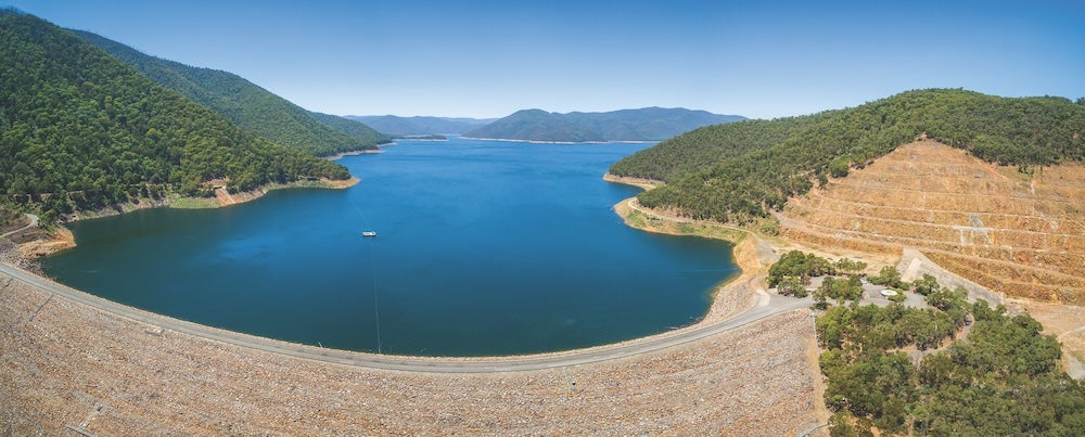
A multi-million-dollar upgrade of the spillway gates at Meadowbank Dam has been recently completed by Hydro Tasmania. The works replaced the 20 x 4.2-tonne hydraulic cylinders with new lighter models from Europe and were carried out over two summers and.
After consulting with the community, the upgrades were split into two stages to minimise disruption during peak holiday and irrigation periods. Works were also carried out with the water level as high as safely possible to lessen the impact on lake users.
“Doing the upgrades with the water level higher than usual meant we got a shower or two but we knew it was important for the community to be able to use the lake over summer,” said Hydro Tasmania Project Manager Andrew Rumsby.
The newly upgraded crest gates have since seen extreme rainfall and have performed well and as expected in such weather conditions. The works are part of Hydro Tasmania’s A$1.6 billion programme of upgrades to optimise and modernise its hydropower network over the next ten years.
CEO Ian Brooksbank said the plan included major refurbishment across ten power stations and five dams in order to extend operational life, and improve capacity, reliability and flexibility.
“Our incredible hydro network has played a significant role in fuelling Tasmania’s economic growth but it can’t stand still in time,” he said. “We must invest in our infrastructure for a new era of Tasmanian hydropower that will help meet the state’s energy demands now and in the future.”
Brooksbank said the capital works complemented plans to redevelop the Tarraleah Hydropower Scheme and to build pumped hydro at Lake Cethana, while major upgrades are underway at the 432MW Gordon and 360MW Poatina hydro power stations.
“Works of this scale take years of engineering and logistical planning, especially when you consider they are occurring deep underground,” Brookbanks acknowledged. “A big shout out to the team at Gordon who just lifted the 173-tonne stator. This is the heaviest lift we do and it’s a rare event involving two cranes and millimetre-level precision.”
Dartmouth anniversary
Built in the 1970s, Dartmouth Dam is approaching 45 years in operation. Operated by Goulburn–Murray Water (GMW) on behalf of the Murray–Darling Basin Authority (MDBA), its enduring role in Australia’s water management is described as being: “both testament to the engineering methods of the time and the collaborative efforts of the Australian Government and the governments of Victoria, New South Wales and South Australia in funding its construction”.
The primary purpose of Dartmouth Dam is to conserve water during wetter periods as insurance against future drier times. Its management is governed by the rules of basin governments under the Murray–Darling Basin Agreement.
The 180m high rock structure is the largest capacity dam in Victoria. At full capacity its reservoir can store 3856,000 megalitres. GMW Acting Operations Manager, Mark Muldeary, oversees day-to-day operations of the dam. It’s a role, he says, that is taken incredibly seriously and relies upon a strong partnership with the MDBA.
With the impact of climate change and a drying climate, Dartmouth Dam has never been more important as in dry seasons the storage supplements releases from Lake Hume and increases supplies to the River Murray system. The dam not only plays its main role in drought preservation but plays a critical one in managing floods. MDBA General Manager of Assets, Angus Paton, says it’s an asset of national significance, given its critical role in water security.
Basin plan peview
Andrew McConville, CEO of Murray Darling Basin Authority, recently shared the Australian experience of water policy reform.
Known as the driest inhabited continent, when faced with prolonged drought and competing demands for water in the late 1990s and early 2000s, Australia witnessed the decline of wetlands and river health in the basin.
The largest and most complex river system in Australia, the Murray Darling basin spans more than one million square kilometres and crosses the borders of five out of eight states and territories. It is also Australia’s largest area for agricultural production, producing more than A$US20 billion worth of food and fibre every year, with its rivers and lakes supporting a unique habitat and rich biodiversity – critical to the survival of more than 120 waterbird species and 50 native fish species.
Good governance and collaboration were critical to put the basin back on a sustainable footing and arrest the decline of biodiversity, McConville says. Established in 2012, the Murray–Darling Basin Plan was an “essential course correction” to bring the basin’s back from the threshold of historical overextraction and the compounding pressures of the millennium drought.
Introduction of the Basin Plan was heavily contested though as it put a cap on water use and sought to make water available for the environment. Enshrined in national law, it is essentially an agreement between state and federal governments to manage the basin’s water with consideration of the country’s social, economic, cultural, and environmental outcomes.
“It sounds simple enough. Yet the system is complex – both geographically and politically,” McConville goes on to explain. “The last 12 years of Basin Plan management and practised collaboration have built on over 100 years of often challenging relationships. The path for stakeholders to seek local action and answers is difficult to tread. Not only are multiple agencies involved in water management, there are also many political, economic and environmental drivers at play. We have a thousand stakeholders with diverse perspectives on water sharing priorities.”
Although we agree we want a healthy and sustainable basin for future generations to enjoy, McConville says the ‘How’ is where the challenge lies.
Purpose of the plan
The Basin Plan’s purpose is to improve the health of the Murray−Darling Basin and sets the amount of water that can sustainably be taken from the basin each year. It aims to contribute to:
- Maintaining healthy rivers that support resilient and thriving communities
- Protecting key environmental systems and assets
- Identifying First Nation people’s water management objectives and outcomes desired by them
- Supporting productive communities and confident industries including agriculture.
Set to be reviewed every ten years, with the first review in 2026, the review is seen as an opportunity to reflect on lessons learned, what’s working and what might need to change to support the basin as the climate changes. In preparation for this, some of the basin’s most complex challenges are being worked through. The four themes for the 2026 review are:
- Climate Change
- First Nations
- Sustainable Water Limits
- Regulatory Design
In support of successful environmental outcomes, new and updated science and knowledge is helping to understand the current environmental condition of the whole basin, and how this may change in the future. These include:
- Updated river models
- Updated environmental condition and trend reporting
- First Nations people’s science and knowledge that they consent to share
- Hydroclimate information.
If it is found that environmental outcomes are not being achieved, the authority says it will work with basin communities and explore a range of available options. MDBA says there is a lot to learn from First Nations people, who’ve been managing country’s land and water for over 65,000 years. It is seeking to partner with them to work respectfully with their science and knowledge to support understandings of the complex links between climate, flow and environment.
And with key differences between the northern and southern basin such as rainfall patterns, the ability to store water and control river flows with infrastructure, and the ability to manage water flow, water needs to be managed differently in both regions. MDBA says greater flexibility in the basin plan may be needed to achieve its desired outcomes.


