

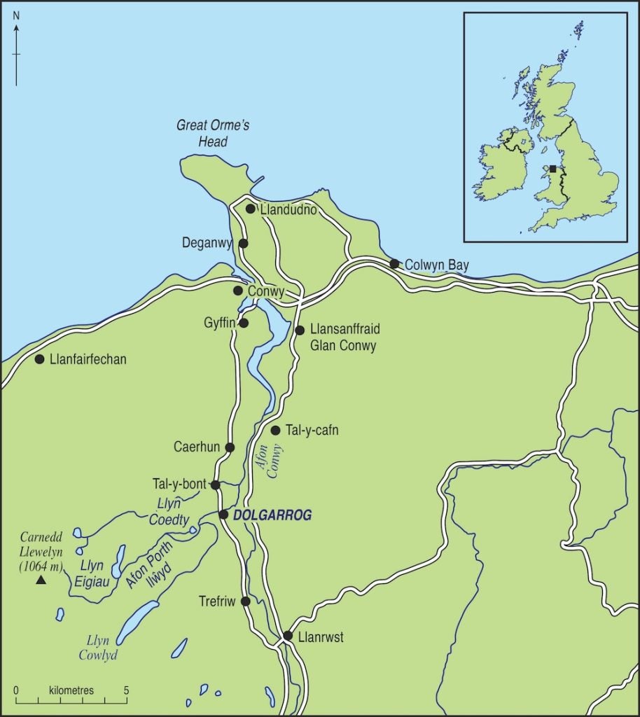
Just over one hundred years ago, on 2 November 1925, a catastrophic dam-break flood carrying enormous boulders swept through part of Dolgarrog village and the hamlet of Porth-llŵyd, in north Wales, destroying homes, a bridge, and the local chapel. The flood entered the aluminium smelting works and power station, resulting in a power blackout across the region. After the flood, the inundated areas were unrecognisable, and the main river (Afon Porth-llŵyd) had rerouted its path. Ten adults and six children lost their lives.
This devastating flood was caused by the failure of two dams impounding the Eigiau and Coedty reservoirs on the Carneddau plateau, high above Dolgarrog. It was the last dam disaster in the UK to result in loss of life and the final catalyst that led directly to the Reservoirs (Safety Provisions) Act of 1930, which heralded a new era in dam safety, construction and inspection.
This new legislation was applied to all reservoirs of a volume greater than ~ 22,730m3 and required all reservoir construction to be designed and supervised by a competent engineer, with regular inspection and certification by a competent independent engineer every ten years. It was the first attempt in the UK to regulate the design, construction, and maintenance of reservoirs through statutory safety measures, and required water levels and leakages to be monitored.
Current research
Our current research aims to reconstruct the hydrodynamics of the Dolgarrog flood and quantify the mechanisms of erosion and sedimentation related to the event. The disaster was notable, not only as a milestone in UK reservoir safety, but also due to the nature of the flood hazard which resulted from a cascade failure of two dams.
The upstream Llyn Eigiau cyclopean concrete gravity dam, completed in 1911, impounded 4500 x103m3 of water, was 1200m long, and had a maximum height of 10.5m. The downstream Coedty embankment dam, constructed in 1924, impounded a small reservoir of 320 x103m3. Both dams were constructed as part of a hydropower scheme providing electricity for the local aluminium smelting works in Dolgarrog, with excess production exported to the energy grid.
At around 8:45pm on Monday 2 November 1925, Llyn Eigiau dam’s foundations failed. This was caused by a blow-out in the underlying sediments that breached the base of the dam (described in the aftermath as a ‘cauldron of emergence’) and resulted in a flood channel approximately 20m wide and 3m deep being eroded into the open moorland.
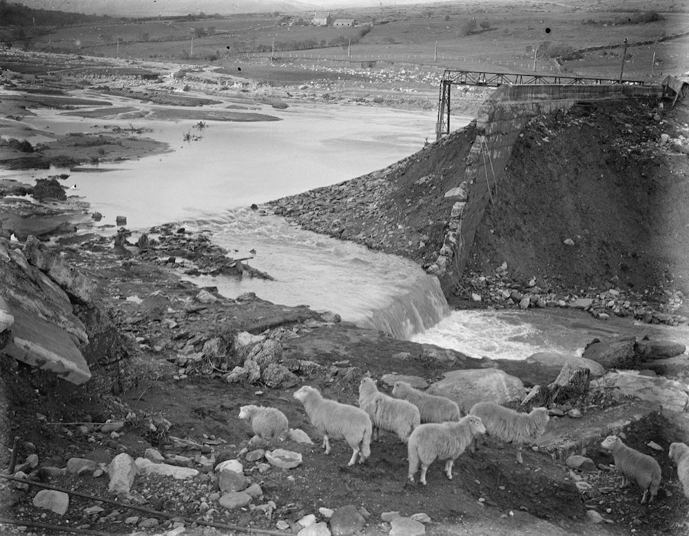
The dam-break flood surged 4km down the Afon Porth-llŵyd to the Coedty reservoir, which filled in minutes. The Coedty dam was then overtopped by the inflow and failed catastrophically, releasing a flood estimated at ~1.7 million m3.
Within minutes, sediment-laden flood waters plunged 230m down the final 2500m of the Afon Porth-llŵyd into the village. Enormous boulders up to 5m in length were excavated from the bedrock gorge and swept onto the lower valley slopes and Afon Conwy floodplain, depositing an extensive fan of debris, destroying buildings and burying infrastructure.
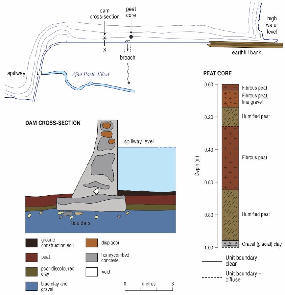
Following the disaster, the Coedty dam was rebuilt. The Eigiau dam was never reinstated but has been left as a reminder of the disaster to the present day. Several key factors contributed to the failure of the upper Eigiau dam, most notably:
• The shallow depth of the foundations, which were grounded in a weak glacial clay below a thick layer of peat.
• The summer prior to failure had been very dry, resulting in the exposure of the base of the dam wall and shrinkage of the peat and desiccation of the clay substrate, which were then rapidly rewetted during a wet October.
• The very poor quality of the cyclopean concrete used in the construction of the dam, which was full of voids and structural flaws.
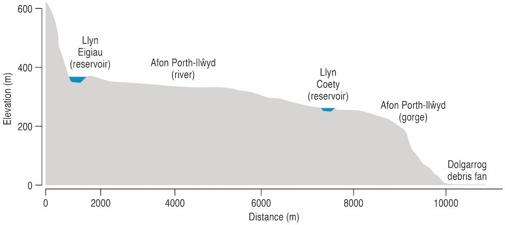
The long profile of the Afon Porth-llŵyd, from its source at Llyn Eigiau to its eventual confluence with the Afon Conwy, contributed significantly to the impact of the disaster. The overall long profile form is convex upward, in as much as the gradient of the channel increases dramatically downstream of the Coedty reservoir.
Therefore, the force of the dam-break flood released from the headwaters, and the ability to entrain debris and sediment, increased downstream rather than decreasing along a long profile of reducing gradient. In the UK uplands, this long profile form is not uncommon, and many upland reservoirs are also located close to large areas of population where downstream settlements and critical infrastructure could be affected by a dam failure.
Important legacy
An important legacy of the Dolgarrog disaster, and the legislation that followed, is that it helped to ensure that no further fatalities by dam failures have occurred. However, there is increasing concern that given ageing dam infrastructure in the UK and a changing climate, there is the potential for an increased risk of future failures.
Most reservoirs in upland Britain were constructed in the 19th century under hydrological conditions that no longer hold1. Embankment dams and older masonry dams can be especially vulnerable to erosion, seepage, slope instability or overtopping. UK Climate Change Projections (UKCP18), which illustrate a range of future climate scenarios until 2100, predict a greater chance of hotter, drier summers and warmer, wetter winters, both with more extreme weather events. Models predict that intense rainstorms that cause flash flooding will be five times more likely by 2080. Steep UK upland catchments underlain by hard impermeable rocks, where much of the UK’s water storage infrastructure is located, are especially vulnerable to flash flooding.
In late July 2019, the evacuation of more than 1500 residents from Whaley Bridge downstream of Toddbrook reservoir in Derbyshire, England, was ordered. Toddbrook had received a month’s rain (160mm) between 27-31 July, and swollen inflows overtopped the dam’s emergency spillway, causing erosion of the concrete lining. This erosion exposed the dam’s core, raising fears of a breach2.
Following the Toddbrook reservoir incident, the UK government commissioned an Independent Reservoir Safety Review Report, which identified systemic weaknesses in the reservoir safety regime and called for a new hazard classification and safety management system.
Geomorphological considerations
As a team of geomorphologists who work on river processes and landforms, we are interested in the landscape-changing effects of such dam-breach floods, and how a combination of substrate properties, catchment topography and flood hydraulics can amplify the dam-breach flood hazard to communities.
The 1925 Dolgarrog disaster serves to highlight the dangers of ignoring such factors, treating them cursorily, or viewing them in isolation. We advocate strongly that such geomorphological considerations be an essential part of flood emergency planning and hazard assessment.
References
1. Woodward, J, Warburton, J. and Tooth, S. (2025) Dam disasters of the 1920s made reservoirs safer – now the climate crisis is increasing risk again The Conversation. https://doi.org/10.64628/AB.q5vupyhtx
2. Balmforth, D. (2020) Toddbrook Reservoir Independent Review Report. PB 14612 https://assets.publishing.service.gov.uk/media/5e6f3f56d3bf7f2690785d52/toddbrook-reservoir-independent-review-reporta.pdf
Author details
Professor Jeff Warburton, Department of Geography, Durham University, Lower Mountjoy, South Road, Durham, DH1 3LE, UK
Professor Jamie Woodward, Department of Geography, The University of Manchester, Arthur Lewis Building, Oxford Road, Manchester, M13 9P, UK
Professor Stephen Tooth, Department of Geography and Earth Sciences, Llandinam Building, Penglais Campus, Aberystwyth University, Ceredigion SY23 3DB, Wales
Dr Hywel Griffiths Department of Geography and Earth Sciences, Llandinam Building, Penglais Campus, Aberystwyth University, Ceredigion SY23 3DB, Wales


